Navigating New Zealand - Field Work Fun
- Leah Sacks

- Oct 18, 2023
- 5 min read
This week, I’ll be discussing field work. Specifically, I’m supposed to discuss my most memorable field experience and what I learned. While this is a topic I would love to discuss at length, I will have a finite amount of time to present about it to my colleagues, so this post is tailored to that amount of time. As I went to write this blog post though, I realized that I mostly wanted to show pictures and discuss what was in them. So, I will give a short introduction and then I will give captions to my pictures discussing what is depicted.
My most memorable field experience was in New Zealand or Aotearoa as it is named by the native Maori people. I did a “study abroad” trip there, which was really more like an extended field school. We stayed in 14 locations over 10 weeks, and went to different field sites every day. Because of the number of places we went, it is impossible to cover everything, but I’ll try to hit the hot spots (literally and figuratively).
We spent the first 5 weeks on the North Island of NZ, piecing together the geology of the island, and then the second five weeks on the South Island, doing the same. Interestingly, there are very separate (though related) histories for each island. Again, I’m not going to go into detail, but I’ll give a little overview.

NZ is located on the boundary of 2 tectonic plates, the Pacific and the Australian plates. However, they are not colliding exactly straight on. On the North Island, the two plates primarily form a subduction zone, with the Pacific plate (to the East) subducting under the Australian plate. To the south, the two plates collide in an orogenic zone, forming the Alpine Fault and the mountains of the Southern Alps.
Due to the suduction zone, the North Island geology is governed by a mix of volcanic and sedimentary processes, including the evidence of changing sea levels over time. First, is the TVZ, the Taupo Volcanic Zone. This is a wedge of land where hyrdration melting from the subjecting plate has caused volcanism at the surface. A large caldera, Rotorua Caldera, several well known volcanoes, and some hot springs all reflect the history of the island. Interestingly, they also reflect the way the type of volcanism correlates with geographic location. There is a tear in the subjecting slab, and that tear as well as the different geometries of the subjecting slab, has led to stronger volcanism in certain areas and steam and hydrothermal activity in other areas.
We stayed right in the hear of the TVZ for one of our stops and had to consider the danger of lahars. Essentially, if enough water gathered at the top of one of the volcanoes and breached the sides of the caldera, a huge mud, rock, water landslide slurry would come raging down the mountain and wipe out the campground we stayed in.


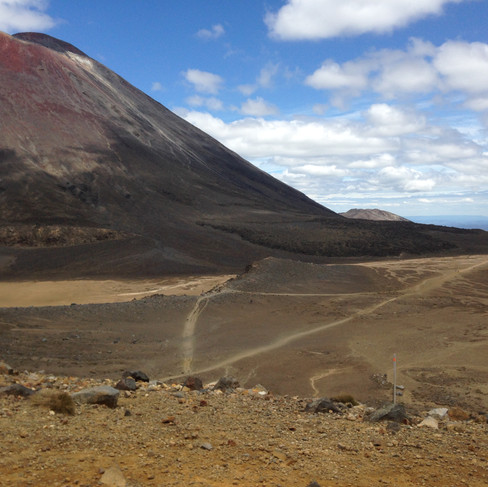


We did a huge hike called the Tongariro Crossing, which gave me amazing up close pictures of the tops of volcanoes.

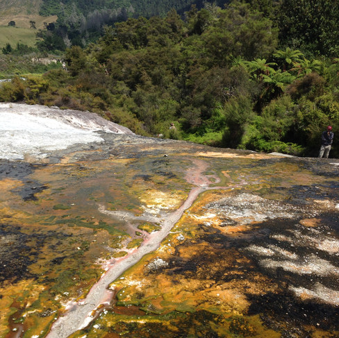


We visited hot springs on two separate occasions and saw some very cool sintered terraces.


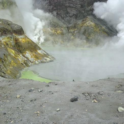
We also went out to White Island, which was in the news a little while back for erupting. It’s an island of the north-eastern part of the North Island that is largely a sulphuric hydrothermal system that periodically explodes as an eruption. For a while, there was a sulphur mine there, but it wasn’t sustainable. We wore gas-masks to visit!

The subducting slab also creates an accretionary wedge along the south-eastern border of the island. We saw the angled strata as well as participated in a sample SEISMIC demonstration where we attempted to draw in faults in reflection data, to understand the subsurface.
There is one volcano that is not super well explained by the subducting slab, the Egmont volcano. So that is an ongoing mystery.


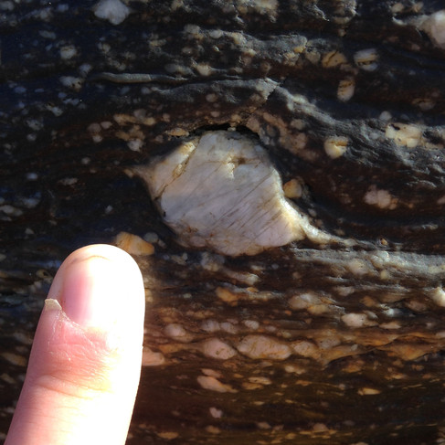
On the South Island, we saw many different things relating to the colliding plates and the mountains. We saw mylonites, which are rocks formed in high strain zones of a particular type, which had lots of great shear sense indicators in them! We also saw some areas that reflect the collision zone of the two plates and are therefore really mangled.


We also mapped the geology of a peninsula, which had a bunch of seals around it. This gave us lots of practice with a Brunton and our second field mapping exercise. It turned out that there was a large scale syncline-anticline pair forming the peninsula. We also went swimming with dolphins! Which I had to include because it was an amazing experience even though I felt nauseous the whole time. Which is really saying something. It was an eco-friendly type of dolphin experience where we go out to meet pods of dolphins and they are not domesticated, touched, or harmed in any way. We saw a sperm whale dive as we were coming back from the dolphins!


We also saw two glaciers up close, the Franz Joseph and the Fox glaciers, and learned about glacial retreat and the rocks, ice, and rivers left behind. There were markers showing where the glacier had ended each year. We also toured the fjords carved by retreating glaciers.

Christchurch, one of the bigger cities on the South Island, experienced major earthquakes in 2010. This was about 6 years before I was there, so there was still a lot of evidence of the destruction. 70% of the Christchurch skyline came down as a result of the quakes. We went to a cool shipping container “mall” area that was set up to temporarily house businesses.
This blog post was supposed to cover what I learned and not just my favorite spots in New Zealand, so I'm going to try reflecting a little bit. I've listed some of the information about the geology of New Zealand that I learned, but I really learned a lot about a whole span of geologic processes while I did this trip. New Zealand has almost every geological environment, except perhaps a real desert, and that means I learned the foundations of all of those environments. I did two separate full mapping exercises and spent a lot of time using a Brunton, orienteering, and interpreting outcrops. I learned all of the basics of volcanology, which was not a class offered normally at my institution, and I saw everything from huge volcanic flows to lahar outcrops to hot springs to giant welded tuff layers from old caldera eruptions. I saw glaciers and fjords, mountains and mylonites, cataclasites and giant limestone boulders.
A lot of what I learned comes down to the basic geologic idea that the more rocks you see, the better your intuition and understanding will be for any future rocks you see. I learned that I love to be out in the field, but prefer to sleep on a bed, and that New Zealand is an amazing place. Most of the cities were awesome and unlike Australia, nothing is trying to kill you in New Zealand. We spent some time learning from local Maori people about their history, movements to change the flag and improve inclusion of native peoples. I think that the trip really had me fully experience a new place, a new culture, and new rocks! I also went through the full process of using a wide variety of outcrops to piece together the geology of the North Island. Our instructor only gave us pieces of information as we went along, so we were really building the story of what happened as we went. It was a large exercise is critical thinking and geologic understanding. We had to present and defend our ideas at various locations, continuing to expand the picture.
I've jumped around a little bit, but essentially, I learned more in the 10 weeks I spent in New Zealand than any other 10 week period of my life. It was an amazing amount of material condensed into that time-frame, but it was fantastic and I can't wait to go back some day.


Comments